 Nearly a century after Marco Polo made the journey he details in The Description of the World, the equally legendary Moroccan traveler Ibn Battuta began his own voyage from Calicut, India to Quanzhou in far Cathay. He followed the “Silk Road of the Sea,” passing through the Maldives, Ceylon, Sumatra, and came to port in a land called Tawalisi. There, he writes, he had an audience with its sovereign, a woman-warrior of great renown named Urduja, who presented him with gifts of “robes, two elephant loads of rice, two buffaloes, ten sheep, four pounds of syrup, and four martaban (large jars) filled with ginger, pepper, lemons and mangoes, all of them salted, these being among the things prepared for sea voyages.” While scholars have yet to pinpoint the exact location of Tawalisi, many believe it lay somewhere along the shores of the Lingayen Gulf, in the province known as Pangasinan.
Pangasinan, “where salt is made,” was a name already famous with traders of the Tang, Song, and Ming dynasties of China long before the arrival of the Spaniards. Back then though, the name only referred to the region’s vast coastal area where salt making was and is still practiced. “Caboloan” was what the inland region was called, from bolo, a species of bamboo abundant in the area and favored in the weaving of light baskets and native plates called bilao.
The Spanish conquest and colonization of Pangasinan began in 1571, when Martin de Goiti finally reached the province by way of Pampanga. In 1580, Governor General Ronquillo de Penaloza made the region an Alcaldia Mayor, and in 1611, Pangasinan became a province that included present-day Zambales and parts of La Union and Tarlac. Lingayen was named provincial capital and remains so to this day. For a modern-day exploration of Pangasinan, it is one of the best places to start.
Lingayen and Dagupan
Lingayen will always be remembered among the veterans of the last World War. In the morning of January 9, 1945, American Liberation Troops finally began landing on the beach just behind the Provincial Capitol, paving the way for the liberation of Luzon and eventually the Philippines from Japanese occupational forces. Today, a motley arsenal, including two M24 tanks, anti-aircraft artillery, and a Japanese Zero, remains in the public park in the capitol grounds.
For students of history, the Limahong Channel is also a definite attraction. In 1574, the Chinese corsair Limahong, failing to take Manila from the Spaniards, turned his ships north and attempted an invasion of Pangasinan. Repelled once more and now pursued by the Spanish army, he and his crew dug a channel from Domalandan to the South China Sea that served as his escape route and his lasting imprint on the land he failed to besiege. A bridge with a marker now spans the channel that has been widened by centuries of erosion.
 If you want to catch Lingayen at its most festive, the best time to visit would be during the annual Pista’y Dayat celebration every first of May. A Thanksgiving Mass celebrated at the Lingayen Public Beach normally opens the festivities. A traditional fluvial parade often follows, and various cultural shows and contests are put on for the entertainment of both locals and visitors. You’ll get to sample fabled Pangasinan cooking and local delicacies like puto calasiao (chewy rice dumpling) at every house you visit. Wash everything down with a glass or two of duhat (blackberry) wine (beware, it is very potent). If you’re looking for bagoong (salted fish paste), you’ve come to the right place. Maniboc, as it is called in Lingayen, referring to its place of origin, Barangay Maniboc, is claimed to be the best in the world.
The day after, if you prove to be highly tolerant to the effects of duhat wine and are still stricken with fiesta fever, head down to Dagupan. The annual Bangus (Milkfish) Festival, celebrating the Dagupan milkfish harvest, will most likely be in full swing. Among the festival’s attractions are the “101 Ways of Cooking Bangus” and the “Longest Grill” competition (Dagupan currently holds the Guiness World Record).
Alaminos
Scattered off the coast of Lucap in Alaminos, the more than 100 limestone islands of the 1,844-hectare Hundred Islands National Park are the province’s most popular destination and one of the best places to go when you finally get tired of Lingayen and Dagupan’s urban atmosphere.
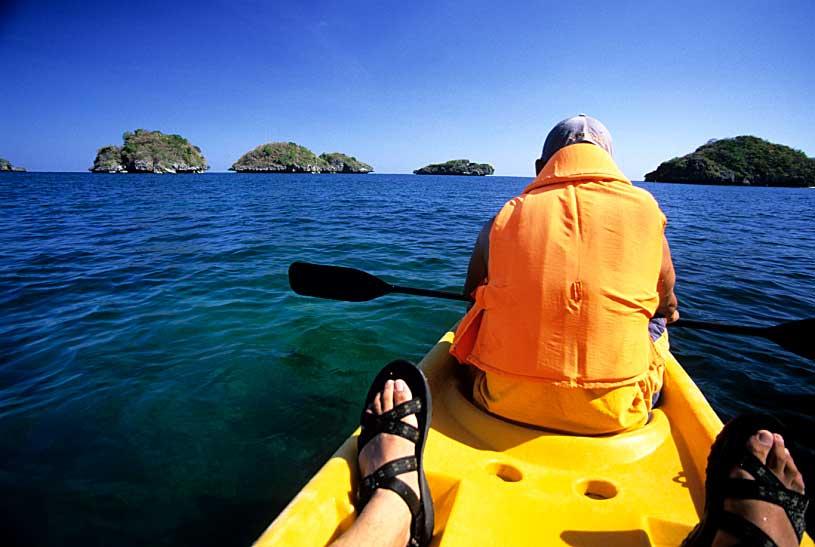 From the Lucap Wharf, a twenty-minute ride via motorized pumpboat will bring you to the closest of the islands. The water is shallow in many places between the islets, making them ideal places for swimming and snorkeling. Unfortunately, many of the coral reefs have been damaged by years of dynamite and cyanide fishing as well as by typhoons and the ravages of El Nino. Though steps have already been taken to protect whatever is left, the total revival of the reefs will take more than one human lifetime.
Of all the islands in the park, only a handful have beaches, the majority being nothing but mushroom-shaped outcrops, rising out the jade-colored water like giant green-backed turtles warming themselves in the sun. Quezon, Governor’s, and Children’s Island, the largest of the islands (Quezon Island is the largest of the three), provide picnic tables, pavilions, and grills. All can get very crowded on weekends.
If you have intentions of acting out your Robinson Crusoe fantasies, you can ask your boatman to drop you off on another island. There are many much less-frequented ones with very interesting and appealing features: Marcos Island has a blowhole that you can enter during low tide with a kayak, Cuenco Island has a cave with openings on opposite sides of island, Scout Island also has a cave, plus an offshore reef for snorkeling and small white beach where you can set camp and read Neruda while the sun sets.
Bolinao, Dasol, and Mabini
Once you get your fill of the Hundred Islands, Bolinao is the logical next step in your modern-day journey. If Tawalisi was truly located on the Lingayen Gulf, this fishing town on the northwestern tip of the Pangasinan crescent could just be one of its probable locations. Even before the arrival of the Spaniards, Bolinao was already a prosperous trading center. White and blue Ming porcelain has turned up in many archaeological dig sites along Bolinao’s rugged coastlines. The remains of sunken Chinese junks are believed to be lying just offshore, probably among the numerous reefs that dot the area’s wide expanse of unspoiled seascapes. The small Bolinao Museum houses a few archaeological finds, including ancient burial jars, crockery, and the remains of a prehistoric elephant.
 Three centuries of Spanish colonial rule have also left its mark in Bolinao. The Church of St. James, with its façade of dark coral, was built by the Agustinians in 1609. This fortress of a church is famous for its wooden images of saints and its antique altar flanked by two grinning, tongue-wagging, Aztec visages, said to have been brought from Mexico by the Galleon Trade. You climb to the top of its renovated belltower for a sweeping view of the entire town. But if you fancy aerial views, none can match the view atop the Cape Bolinao Lighthouse atop Punta Piedra Point in Barangay Patar, 12 kilometers from the town center. Built by the Americans in 1905, the lighthouse rises 351 feet above sea level. The only other lighthouse perched on a higher promontory would be the one overlooking Cape Bojeador in Ilocos.
Make the most out of your trip to Patar by heading down to Patar White Beach. You can watch fishermen come in from the sea with their day’s catch. Or you can head out into the big blue yourself and catch some incoming surf. Pass by Enchanted Cave and Cindy’s Cave on your way back to town. At the mouth of Balingasay River, the cleanest in Luzon, you can rent a boat; travel inland and try to find its source.
Back in town, head into the direction of Port Bolinao and stop by the Marine Science Institute of the University of the Philippines. In an effort to restore Pangasinan’s reefs, the Institute cultivates near-extinct indigenous species of coral, giant clam, abalone, and sea urchin with the aim of eventually transplanting them back into their natural environment. You can see the extent of their work for yourself by diving off Santiago Island off Port Bolinao. Unlike in Patar, the beaches on this part of Bolinao are not as inviting. Take a day trip to nearby Dasol and go to either Tambobong Beach or Colibra Island. The sand there is as white as the salt made by the locals in the same method their ancestors probably used almost a millennium ago. If caving is your fancy, the Cacupangan and Villacorta Caves in Mabini are just waiting to be explored.
Manaoag and Calasiao
A trip to Pangasinan will not be complete without passing by the religious shrine of Our Lady of the Holy Rosary in Manaoag. Patroness of the sick, the helpless, and the needy, “Apo Baket” as she is called celebrates her yearly feast from April 14 to 16. Dawn processions are held every first Saturday of the month as well. Believing her image to be miraculous, devotees line up for hours just to get a chance to touch her feet from an opening at the back of the altar.
 Not more than fifteen minutes away by car from Manaoag, housed in a shrine of its own across the Parish of Sts. Peter and Paul, just beside the municipal building of Calasiao, and not far from the roadside stalls of the alluring all-female puto calasiao vendors, the Senor Divino Tesoro, draws an equally large number of devotees every day of the week and especially on its feast day from May 1 to 3. The image of the crucified Christ is supposed to have grown from a little boy to the man he is now. As in Manaoag, believers will wait hours in a slow-moving line, many lost in the mysteries of the Rosary, just to touch the image of the Senor and receive his blessing.
While many believe Princess Urduja’s Tawalisi truly exists, a number also argue it could only be found somewhere in Captain Gulliver’s Atlas, along with the other fairy tale lands ruled by great priest-kings and fierce warrior-princesses. But Pangasinan, though itself a land of myths and heroic tales, is as tangible as the taste of bagoong in pinakbet. To travel through its varied landscape is to glimpse history and gain further insight on the Filipino people. The discoveries we can make in this beautiful land? Hundreds. (JG)
1 comment:
Grabe ang ganda talaga ng photos mo.
You should really put up your own photography workshop. :P I'm gonna join. Haha. :D
Post a Comment